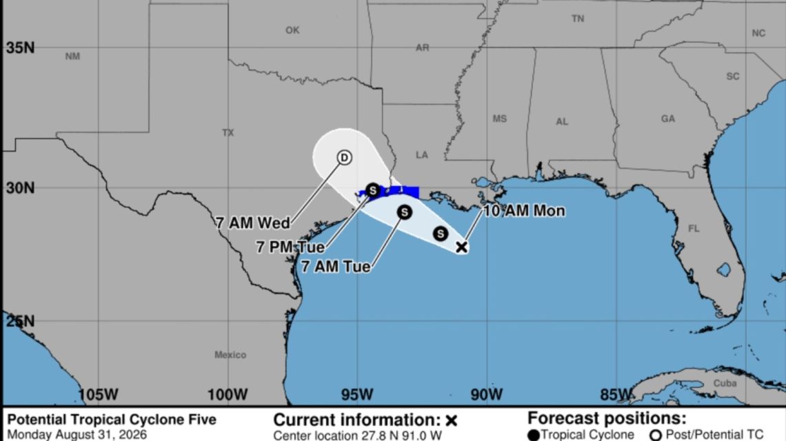
A tropical rainstorm is set to hit the northern Gulf Coast, bringing heavy rain and flash flooding to sections of Texas and Louisiana this week. The National Hurricane Center (NHC) has indicated that while this storm might not bring significant wind, rainfall will be a major concern as it approaches.
NHC Advisories and Forecast
On Monday, the NHC began tracking Potential Tropical Cyclone Five in the northwestern Gulf. With sustained winds of 35 mph, tropical storm warnings were issued for parts of the upper Texas and southwestern Louisiana coastlines as the system moved west-northwest at about 5 mph. According to forecasters, the storm has an opportunity to develop into a tropical depression or storm before its landfall on Tuesday, although major strengthening is not anticipated. If it attains tropical-storm strength, it will be named Edouard.
Rainfall and Impact Forecast
The storm is expected to hit coastal Louisiana first before moving into southeastern Texas, including the Houston area. Windy.com shows possible heavy rain over the upcoming days in these regions. Some places might see as much as 9 inches of rain.
“PTC Five is expected to produce rainfall totals of 3 to 6 inches with maximum totals of 9 inches for parts of the Upper Texas Coast inland through east-central Texas, with 2 to 3 inches for Southwest Louisiana,” the NHC stated. “This rainfall may trigger flash flooding, especially in urban areas and low-lying regions.”
AccuWeather forecasts widespread rain totals of 1 to 2 inches along the Louisiana coast and into eastern Texas through midweek. In the Houston area, 2 to 4 inches could fall, with isolated places seeing as much as 12 inches through Wednesday due to persistent storms. The greatest rain is anticipated from Monday night into Tuesday, raising concerns about road flooding and travel delays during busy commuting times.
Satellite imagery from windy.com shows the storm nearing the coastline as of late Monday morning. Intense downpours could cause swift flooding even in areas not receiving the highest rainfall, overwhelming drains and leading to standing water. Motorists are often urged to avoid driving through flooded streets due to potential dangers hidden beneath floodwaters.
Wind and Long-term Weather Impact
Wind is expected to play a secondary role, though gusty winds can occur along the coast and within intense storms. Dangerous surf conditions are likely for small craft. However, major wind damage or coastal flooding isn’t predicted. After moving inland over southeastern Texas, rapid weakening and disorganization of the system are expected.
Tropical moisture will likely linger along the Gulf Coast most of the week, encouraging further showers and thunderstorms from Texas to Florida. Thus, localized flooding concerns may remain even after the storm dissipates.
 Police Shoot Knife-Wielding Woman in Times Square After She Stabs Two People
  U.S. Senate Candidate Abdul El-Sayed Responds to Fireworks Criticism
  Chaotic Beach Arrest Follows Reckless Driving Pursuit in San Diego
  91-Year-Old Completes Appalachian Trail, Sets Record and Inspires Others
  Increasing Threats to Federal Judges Highlight Need for Enhanced Protection
  Coordinated Response to Major Storm in Northwest Indiana