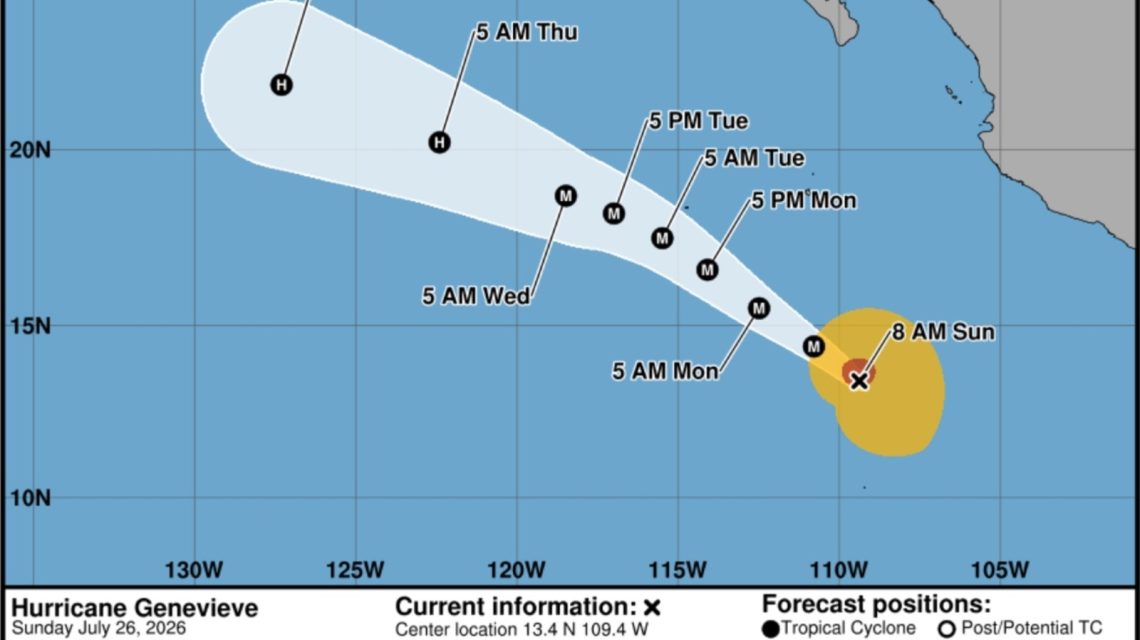
Overview of Hurricane Genevieve
Hurricane Genevieve has marked its significance as the first major hurricane of the 2026 Eastern Pacific season. It has reached Category 3 status, boasting maximum sustained winds of 120 miles per hour. It is currently swirling over the Eastern Pacific Ocean, southwest of Mexico.
Forecasts from the National Hurricane Center (NHC) indicate that Genevieve might evolve further into a Category 4 storm by Monday. Although it’s not predicted to make landfall, there is an anticipation of strengthening before a possible weakening phase later in the week.
Tracking Other Hurricanes
Genevieve isn’t the only storm under observation. Hurricane Fausto is also being monitored; it is headed towards Hawaii. The situation entails a careful watch on how these storms develop and the potential impacts they might cause.
Understanding Major Hurricanes
A major hurricane falls under Category 3, 4, or 5 on the Saffir-Simpson Hurricane Wind Scale (SSHWS), characterized by sustained winds of 111 mph or higher. Such hurricanes possess the ability to inflict severe wind damage and significant coastal effects if they approach inhabited areas.
As Genevieve intensified rapidly, it has become a prime example of the characteristics expected from a major hurricane. If a Category 3 storm approaches land, the NHC warns of “devastating damage.” Well-constructed homes may suffer substantial harm, and numerous trees can be uprooted, causing road blockages. Essential services such as electricity and water may be disrupted for days or weeks.
Current Location and Observations
The NHC pinpointed Genevieve approximately 515 miles southwest of Manzanillo, Mexico, moving west-northwest at about 16 mph. The storm’s central pressure is registered at 963 millibars, a metric denoting its increasing strength.
Weather tracking tools, including animated maps from sources like windy.com, depict the hurricane’s activity off the coast of Mexico. Satellite imagery reveals the pronounced eye of Genevieve in its center, symbolizing its forceful presence.
Impacts on Coastal Areas
Despite heavy rains remaining offshore, Genevieve’s influence is felt along the southwestern Mexican coast. Swells attributed to the storm are currently affecting these regions and likely to extend to the southern Baja California Peninsula by Monday. The NHC cautions that these conditions can lead to dangerous surf and rip currents.
Although Genevieve will persist over open waters, it is anticipated to face cooler sea temperatures and environmental factors that may drive weakening; nevertheless, it is forecasted to sustain its major hurricane stature until Wednesday morning.
Significance of Genevieve’s Arrival
Genevieve’s emergence underscores the opening for high-level hurricanes in the 2026 season within major North American hurricane basins, while the Atlantic sees a phase of quiet with no monitored cyclones.
 Remembering Chris Spatola: ESPN Analyst and Former Army Guard
  Controversy Surrounds Massachusetts’ Proposal for Nurse Home Visits
  Protests Emerge Following ICE Shooting of Venezuelan Man in Austin
  Cold Weather Alerts and El Niño Influence
  Turning Home Food Waste into Compost: A Guide
  Chicagohenge: When Sunlight Aligns with City Streets