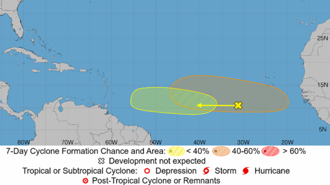
The National Hurricane Center (NHC) is currently observing five areas across the Atlantic and Pacific oceans for potential tropical development, as the 2026 hurricane season intensifies. Although there are no active tropical cyclones presently, forecasters are evaluating a range of disturbances extending from Africa’s coast to waters near Hawaii. The NHC identifies one Atlantic disturbance as having a 40 percent chance of formation over the next week.
Two Atlantic Systems Under Watch
According to the NHC’s Atlantic Tropical Weather Outlook, a wide area of showers and thunderstorms linked to a tropical wave is located a few hundred miles southwest of Cape Verde, Africa. Traveling westward across the central tropical Atlantic, the system may see gradual development early to mid-week. However, upper-level winds, which are fast air currents in the upper atmosphere, may become less favorable by week’s end as the disturbance nears the Lesser Antilles. It has nearly no chance of forming in the next 48 hours and a 20 percent chance in the upcoming week.
Another tropical wave, poised to depart Africa’s west coast shortly, is also being tracked. Conditions are suggested to be more conducive for development, potentially turning into a tropical depression by week’s end while moving westward across the Atlantic. Currently, there is a 40 percent chance of development over the next seven days.
Three Additional Pacific Threats
In the Eastern Pacific, three other areas are being watched for potential development. A significant tropical wave over 1,000 miles east-southeast of Hawaii is generating widespread, disorganized showers and thunderstorms. A tropical depression is likely to form within days as it moves west-northwest across the Central Pacific, with a 90 percent chance of development over the next week.
A second disturbance, south of the Baja California Peninsula, holds a 50 percent chance of development in the next week, whereas a third area poised to form off Mexico’s southwestern coast has a 10 percent chance.
Will Any of Them Hit Land?
The Atlantic systems remain far from coastal areas, and the Pacific disturbances are anticipated to move largely westward or west-northwestward over open waters. As none have developed into a well-defined circulation, predicting their eventual path and strength is challenging.
Why It Matters
The uptick in tropical disturbances suggests the Atlantic hurricane season is becoming more active. Historically, August signifies a rise in tropical activity, with the peak occurring in early September. Although none of the current systems pose immediate threats to the U.S., meteorologists keep a close watch on tropical waves from Africa as they can grow into tropical storms and hurricanes as they migrate west. Presently, the tropical wave expected from Africa this week and the Central Pacific disturbance east-southeast of Hawaii are the most probable to become the next tropical depressions.
Contact Newsweek editors for this story: Matthew Robinson and Robert Greenall.
 Hurricane Developments: Simon’s Intensification and Isaias’ Threat
  Trump Administration Moves to Expedite Arctic Oil Exploration
  Renewed Volcanic Activity At Kīlauea Prompts Trail Closures
  Completion Approaching for World’s Largest Wildlife Crossing in Agoura Hills
  Monarch Butterflies Flourish in Illinois’ Managed Right-of-Ways
  El Niño Strengthens to Historic Levels: What to Expect This Season