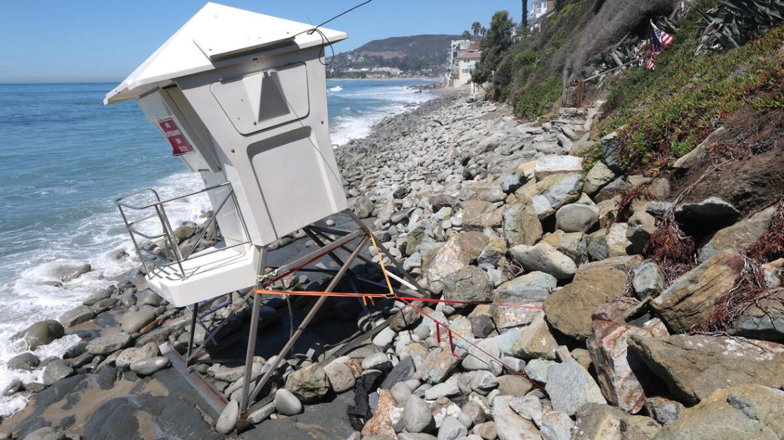
Coastal communities in Southern California are assessing damage from waves and flooding as they prepare for more destructive conditions caused by a coastally trapped Kelvin wave. Homes from south Orange County to Malibu have suffered flooding and severe damage. Erosion has affected the coastline from Carlsbad to Long Beach.
Recently, Laguna Beach, Dana Point, and Carlsbad declared a local state of emergency due to coastal erosion and sand loss from a south swell triggered by Hurricane Marie. El Niño often results in an active hurricane season in the eastern Pacific, where Hurricane Marie formed.
“I’d been chatting with other cities and city managers up and down the coast, and I think we all had different levels of damage,” said Laguna Beach City Manager Dave Kiff. “I think Laguna’s was among the greatest, or most significant, but everybody talked about concern about sand and sand replenishment. They do have sand replenishment projects, from Newport to Huntington to Seal Beach, and then there’s some farther down south.”
A lifeguard tower was secured after waves eroded the sand at Thalia Street Beach. Orange County officials announced the activation of their emergency operations center, which is required when two cities in the county proclaim a local emergency.Our coastal cities are experiencing serious damage, and the county is mobilizing our emergency response,
said Orange County Board of Supervisors Vice Chair Katrina Foley.
Transportation officials posted a video showing severe erosion threatening the train tracks used by Metrolink in San Clemente, with strong ocean waves crashing onto the tracks and sediment crumbling onto the rocks below.It is that serious,
Metrolink stated.
In San Diego County, Carlsbad declared a local emergency to protect Carlsbad Boulevard, also known as Old Highway 101, from severe erosion. Waves have inundated homes along Beach Road in Dana Point.
Impact of El Niño and Kelvin Waves
Another El Niño-influenced phenomenon, a coastally trapped Kelvin wave, is advancing up the coast of Mexico and will soon impact the U.S. West Coast. Forecasters predict damaging storms in the winter, with El Niño likely to be stronger than any since 1950.
The National Oceanic and Atmospheric Administration’s Climate Prediction Center released predictions with a 98% chance of a very strong El Niño during the three-month period ending in December.
Understanding Kelvin Waves
Kelvin waves were previously an obscure concept but are central to El Niño, where ocean waters in the central and eastern equatorial Pacific heat up, affecting global weather. Coastally trapped Kelvin waves follow a coastal boundary, with the shoreline to their right in the Northern Hemisphere.
Michael Jacox, research oceanographer with NOAA’s Fisheries’ Ecosystem Science Division, explained that only recently have scientists had computational capabilities to model and track these waves, as Dillon Amaya from North Carolina State University highlights.
As El Niño develops, typical east-to-west trade winds weaken or reverse along the equator, allowing hot water to move from the western equatorial Pacific eastward, pushed by Kelvin waves.
Warmer water around Indonesia travels east to the cooler part of the Pacific, near Peru. As Kelvin waves move, they split upon reaching South America, with one part heading north toward California and the other south.
Rising Sea Levels
Kelvin waves then become coastally trapped. Along the coast, these waves elevate sea levels and ocean temperatures, pushing cold, nutrient-rich waters deeper below the surface. Kelvin waves can raise sea levels by 6 to 12 inches, potentially for months, increasing flood and beach erosion risks.
The Long Beach Peninsula was recently affected by high waves caused by a swell and high tide, demonstrating the impact of elevated sea levels.
Timing and Travel Path
Kelvin waves are currently near the west coast of Mexico. Amaya expects them to enter the Gulf of California soon, taking about 11 days to travel along the gulf’s coast. From there, it will take another seven days to reach San Diego from Cabo San Lucas, and two to three days more to reach Los Angeles, followed by two to three more to San Francisco.
These waves travel around 25,000 kilometers from the western equatorial Pacific to the Gulf of Alaska, taking about 120 days.
Potential Impacts on Sea Levels
Kelvin waves may cause further sea level rise of approximately 6 inches off the California coast, with effects lasting for months. While it may seem minimal, this rise combined with storm effects could be detrimental, particularly for the already battered coastline.
Jonathan Warrick, a research geologist with the U.S. Geological Survey, noted the damage from high tides and hurricane-generated swells. Elevated water levels can be devastating when factors combine, such as swelling and high tides.
California has experienced about a foot of sea level rise over the last 125 years, driven by human-caused global warming and polar ice cap melting. Additionally, abnormally high tides have been observed recently.
 Managing Drying Rivers: The Need for New Approaches
  Heat Dome Tightens Over South-Central US with Triple-Digit Temperatures
  Army Corps Resumes Construction on Brandon Road Lock and Dam Project
  Impact of Halting U.S. Air Quality Monitoring on Global Pollution Levels
  Persistent Legislative Inaction on Climate Change
  Potential Formation of Tropical Storm in the Atlantic