Joe Blockland, a professor at Indiana University Northwest, has created an app allowing students to analyze trees on campus. After a recent storm, he focused on tree health and engaged his first-semester GIS students in assessing over 400 trees. The goal is to identify issues like cracked trunks and insect holes.
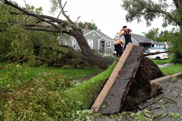
Ricardo Camarena interacted with his neighbor, Rayshawn Hackey, 6, near a tree in Gary, Indiana, illustrating community engagement with the environment. Blockland’s app project motivates students to refine their skills. “Each outing improves their expertise,” Blockland noted. So far, they’ve mapped around 130 trees.
The app aims to benefit local communities and other campuses. Students assist in developing categories for the app. This hands-on experience enhances their local job prospects in GIS. Blockland, who has a background in tree servicing, said the idea for the app felt natural. His familiarity with trees stems from his undergraduate side job and his father’s tree-cutting work.
Beyond tree health, students learn how field data collection can solve problems. Blockland emphasized the high demand for such apps among government organizations and nonprofits. Apps like those used by Ducks Unlimited and the Shirley Heinze Land Trust demonstrate practical applications. Collected data is processed on a dashboard for practical use.
Field data collection has evolved. Cities now recognize the advantages of GIS technology. While some cities lacked GIS budgets, they are now committed to adopting it. Blockland first encountered GIS during his undergrad years, initially disliking it due to technical issues. Yet, he recognized GIS’s value during his graduate studies.
Today, GIS technology advances rapidly. Blockland adapts his classes to keep pace with industry standards. Entry-level GIS salaries range from $50,000 to $80,000, with potential growth as skills improve. Blockland offers a four-course GIS certificate to equip students with necessary skills.
The curriculum includes environmental science and geology, appealing to students across various majors. Beginning students include psychology and art majors, exploring GIS’s role in app creation and city problem-solving. The program encourages students to set aside initial expectations. “The survey course provides a basic tool overview,” Blockland said.
Advanced classes introduce AI tools and database technologies. Environmental GIS focuses on issues like flood mapping and risk identification. Students also learn programming with Python to automate tasks, a skill applicable to industry demands.
Blockland aims for his students to gain a deep interest in GIS through real-world projects. As they progress in their studies, their engagement with GIS should deepen and flourish.
Doug Ross is a freelance reporter for the Post-Tribune.
 Tech Giants’ Record Financing Scramble for AI Expansion
 Challenges and Surveillance in Prediction Markets
 Exploring the Controversies of Authenticity in the Music Industry
 Chesapeake Bay Schools Tackle Blue Catfish Invasion
 Claude AI Model Accesses Georgia Election Data, Raises Security Concerns
 Anthropic’s SEC Filing Ahead of IPO Raises Unconventional Concerns