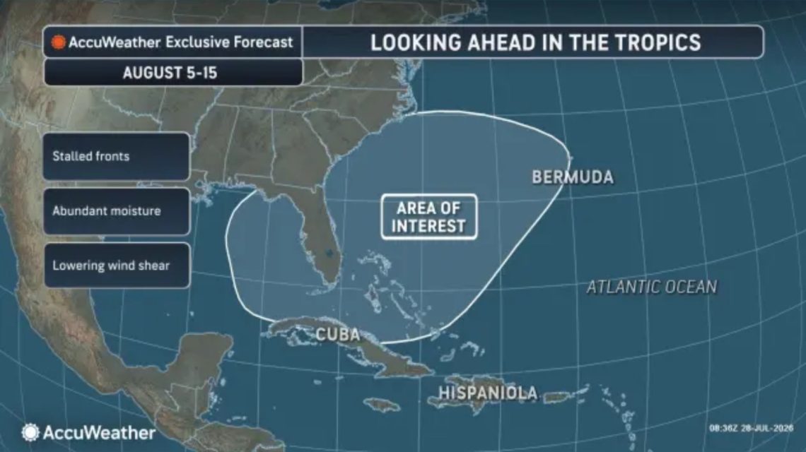
The southeastern United States might be a focal point for potential tropical weather formation in the Atlantic basin through early and mid-August. This information comes from AccuWeather, which noted that while no immediate tropical storms are expected following last week’s storm Bertha, a broad zone near the U.S. coast could become more vulnerable later in the period.
AccuWeather’s area of interest includes the waters surrounding Florida, the Carolinas, Cuba, the Bahamas, and Bermuda. Forecasters suggest this region may have the best chance of leading to a tropical depression or rainstorm between the first and second weeks of August. However, no activity is expected in the early days of the month.
The possibility exists due to expected lower pressure in the region, potentially encouraging thunderstorm development. AccuWeather Lead Hurricane Expert Alex DaSilva explained that weakening fronts are expected to move into the area, and with warm waters and easing wind shear, conditions might become conducive to tropical activity.
One potential development pathway could involve thunderstorms forming an area of low pressure, which may then separate from a declining front. Should this occur, the system might adopt tropical characteristics such as a warm core and rotation, unlike typical nontropical storms driven by temperature contrasts.
The main concern is not the certainty of a storm but the proximity of the risk zone to land. DaSilva emphasized the need for monitoring, as a tropical storm forming near the coast could happen with minimal notice. Such a storm might bring rapid heavy rains, worsen beach conditions, cause coastal flooding, and produce damaging winds, according to AccuWeather.
The early-August anticipation follows Bertha, the second named storm of the 2026 Atlantic hurricane season, which came after Arthur. So far, no hurricanes have emerged this season.
Atlantic Hurricane Season Forecasts
Looking ahead, AccuWeather’s meteorologists forecast a below-average to average Atlantic hurricane season. Today’s conditions, influenced by a strong El Niño, might suppress tropical activity. The National Oceanic and Atmospheric Administration (NOAA), in its May outlook, predicted a 55% chance of a below-normal season, a 35% chance of a near-normal season, and only a 10% chance of an above-normal season.
NOAA’s forecasts range from eight to 14 named storms, including three to six hurricanes and up to three major hurricanes, with a high degree of confidence in these estimates. Typically, an average Atlantic season results in 14 named storms, seven hurricanes, and three major hurricanes.
Hurricane Season Storm Names
The official 2026 Atlantic storm-name list, as published by the National Hurricane Center (NHC), includes Arthur, Bertha, Cristobal, Dolly, Edouard, Fay, Gonzalo, Hanna, Isaias, Josephine, Kyle, Leah, Marco, Nana, Omar, Paulette, Rene, Sally, Teddy, Vicky, and Wilfred. As of Wednesday, the NHC reports no expected tropical cyclone activity in the Atlantic over the next seven days.
 Cold Weather Alerts and El Niño Influence
  Turning Home Food Waste into Compost: A Guide
  Chicagohenge: When Sunlight Aligns with City Streets
  Fat Bear Week 2026: A Look at the Contest and Its Competitors
  California Governor Declares Statewide Emergency Ahead of El Niño Storms
  EPA Rollbacks and the Impact on Indiana Communities