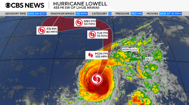
A powerful threat looms over Hawaii as Hurricane Lowell, a major Category 3 storm, nears with fierce 115-mph winds. The National Hurricane Center has issued a hurricane warning for the islands of Kauai and Niihau early Monday. This warning also extends to parts of the Papahanaumokuakea Marine National Monument, spanning almost 583,000 square miles of ocean and incorporating ten of Hawaii’s islands.
The Miami-based hurricane center predicts that the storm’s core will move slightly west of the main Hawaiian Islands by Monday night. It will then reduce its pace by early Wednesday after passing the islands. Although gradual weakening is expected through Tuesday, Lowell is likely to maintain its hurricane status as it moves near Hawaii.
Hurricane-force winds reach outward up to 60 miles from Lowell’s center. The storm may produce additional rainfall ranging from 6 to 10 inches for Kauai, with isolated totals possibly hitting 14 inches. On the Big Island, rain between 4 to 8 inches is expected, with some areas possibly receiving 12 inches. Oahu might see 4 to 6 inches, with up to 8 inches possible in localized areas.
Significant flash flooding and mudslides pose a serious risk, especially in Kauai County and parts of the Big Island. The storm may deliver a surge of up to 3 feet to Kauai County and bring hazardous surf and rip current conditions to many Hawaiian islands.
Moreover, there is the potential for tornadoes on Monday afternoon through Monday night, particularly near Kauai and Niihau. The possibility of twisters exists across other parts of Hawaii as well. Residents should remain alert and prepared for severe weather conditions.
 Python Hunter Helps Capture Record-Breaking Snake in Puerto Rico
 Environmental Concerns Halt Tree Removal at East Potomac Golf Links
 West Virginia’s Nuclear Proposal Faces Local Opposition
 Texas Data Centers Face Criticism Over Water Use Reporting
 First Offshore Mining Lease Sale by U.S. Government
 Unseasonal Warmth Delays Fall Foliage and Brings Impacts