The Atlantic hurricane season of 2026 officially occurs from June 1 to November 30. This year, the National Oceanic and Atmospheric Administration (NOAA) anticipates fewer storms than usual, indicating a below-average season. We provide updates on each storm throughout the season.
Current Storms
There are currently no active storms.
Past Storms
Tropical Storm Arthur
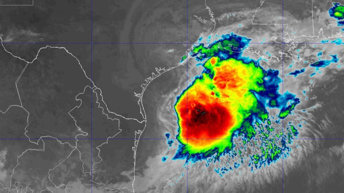
On June 16 at 10 a.m., the National Hurricane Center noted Potential Tropical Cyclone One about 65 miles southwest of Corpus Christi, Texas. It had winds of 30 mph, moving northeast at 6 mph. By 4 p.m., a Tropical Storm Warning for the Louisiana coast was issued from Sabine Pass to Morgan City. The next day at 10 a.m., Tropical Storm Arthur formed 40 miles east-northeast of Port O’Connor, Texas, with winds of 40 mph and moving northeast at 9 mph. A Tropical Storm Warning followed for the Texas coast. By 10 p.m., Arthur transitioned to a post-tropical cyclone with winds at 35 mph, located 35 miles north-northeast of Galveston, Texas.
Tropical Storm Bertha
Initially, Tropical Depression Two formed on July 19 at 10 a.m. about 155 miles south of Panama City, Florida, with winds of 30 mph. It strengthened into Tropical Storm Bertha on July 20 at 7 p.m. 110 miles south of the area, having winds of 40 mph. By July 21 at 10 a.m., Bertha increased to 60 mph winds. The following day, Bertha made landfall in St. Bernard Parish, Louisiana, at 2 p.m., with 45 mph winds. Ultimately, it weakened into a tropical depression on July 23 at 7 p.m., 10 miles north-northeast of Houston, Texas, and dissipated later that night.
Tropical Storm Cristobal
Cristobal materialized on August 12 at 10 a.m., around 880 miles west of the Azores, possessing 45 mph winds and moving east at 25 mph. It weakened to a tropical depression the following day before transforming into a post-tropical remnant low at 10 a.m.
Tropical Storm Dolly
Dolly appeared on August 27 at 10 a.m., 1,555 miles east of the Leeward Islands, featuring winds of 40 mph. The storm dissipated swiftly by August 28.
Tropical Storm Edouard
On August 31, Potential Tropical Cyclone Five formed 130 miles south of Morgan City, Louisiana. It gained force, becoming Tropical Depression Five and then Tropical Storm Edouard throughout August 31. Reaching peak strength on September 1 with 60 mph winds, Edouard made landfall near Johnson Bayou, Louisiana. By September 1 at 10 p.m., the storm reduced to a tropical depression before dissipating on September 3.
Tropical Depression Fay
Tropical Depression Six emerged on September 19, located 525 miles southwest of the Azores with winds at 35 mph. Gaining power, Tropical Storm Fay peaked at 70 mph on September 20. It cycled through weakening and restrengthening phases several times until dissipating on September 29.
Tropical Storm Gonzalo
Gonzalo formed on September 24 at 10 p.m., approximately 190 miles southeast of the Cabo Verde islands with 45 mph winds. Reaching up to 50 mph, the storm dissipated north of Sal, Cabo Verde, by September 26.
Tropical Storm Hanna
Hanna initiated on September 28 at 10 a.m., 870 miles east-northeast of Bermuda, with 45 mph winds. The storm ended on September 30, dissipating far from Bermuda.
Hurricane Isaias
On October 6, Tropical Depression Nine formed 380 miles west of Progreso, Mexico. Advancing east, it became Tropical Storm Isaias and then a hurricane by October 7. It reached Category 3 on October 9 at 7:20 a.m. before reducing to a tropical storm and eventually a post-tropical cyclone on October 10.
 Record Loggerhead Sea Turtle Nesting on Georgia Beaches
  Southern California Secures Safety Amid Coastal Erosion
  Selma Blair Allegedly Involved in Mid-Flight Incident
  Sean ‘Diddy’ Combs Taken for Medical Treatment After Head Injury
  Cities and License Plate-Reading Cameras: A Complex Landscape
  Federal Judge Criticizes Trump Administration for Removing Trees at Historic Golf Course