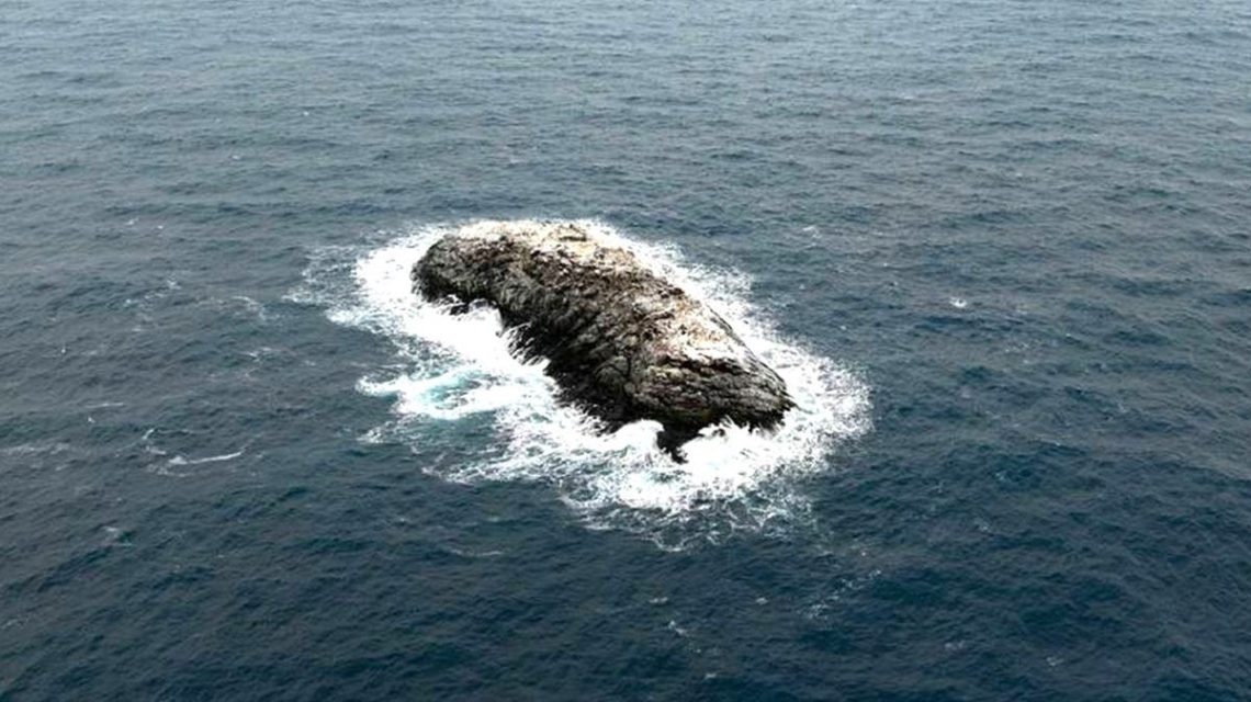
Researchers have identified a previously misclassified Antarctic ‘danger zone’ as an island and mapped it for the first time. The discovery was announced in a press release from the Alfred Wegener Institute (AWI), a German polar research center.
The newly identified island is located in the northwestern Weddell Sea, unveiled during an expedition on the AWI’s icebreaker, Polarstern. Initially, researchers were examining the rapid decline of sea ice in the area. Adverse weather conditions led them to seek refuge on Joinville Island. There, they noticed an unfamiliar topographical feature. On closer inspection, what seemed like a dirty iceberg was confirmed to be a small rocky island.
“On our route, the nautical chart showed an area with unexplored dangers to navigation, but it wasn’t clear what it was or where the information came from,” stated Simon Dreutter, a bathymetry data engineer at AWI.
Dreutter, intrigued by the available coastline records, observed a ‘dirty iceberg’ outside the window. Upon further evaluation, it was established that there was indeed a rocky formation rather than an iceberg. Utilizing drone imaging and echo sounding technology, scientists surveyed this Antarctic island. It was documented as rising over 50 feet above the surrounding water.
The island measures approximately 426 feet in length and 164 feet in width, protruding around 16 meters (52 feet) above water. Officials are uncertain why it was classified as a danger zone. It visually resembles surrounding icebergs, making aerial identification challenging.
A Polarstern representative explained that the topography might involve uncharted shoals on the seafloor, characterized by abrupt changes in water depth over short distances. The team mapped this new landform using satellite data in low resolution, noting it as a gap in nautical charts.
Although yet to be officially named, the island will undergo the formal naming process with a submission to the Scientific Committee on Antarctic Research (SCAR) for review. Officials highlighted the minimal charting of the Weddell Sea, emphasizing unexplored areas in Antarctica.
“Since satellite observation, even in the remote areas of Antarctica, the discovery of an island is a rare and exciting event,” the spokesperson commented.
With only a quarter of Antarctic waters charted, researchers foresee potential discoveries of seabed landforms in other uncharted regions.
 Viking Age Discovery in Denmark Reveals Advanced Textile Production
  U.S. Fish and Wildlife Service Expands Shellfish Classification
  Tubulin Identified as Key Player in Combating Alzheimer’s and Parkinson’s
  The Mystery Behind Coho Salmon Deaths: Tire Chemicals
  Ancient Interstellar Comet 3I/ATLAS Offers Unprecedented Insights
  Abandoned Puppy and Cat Find Safety in Humane Society