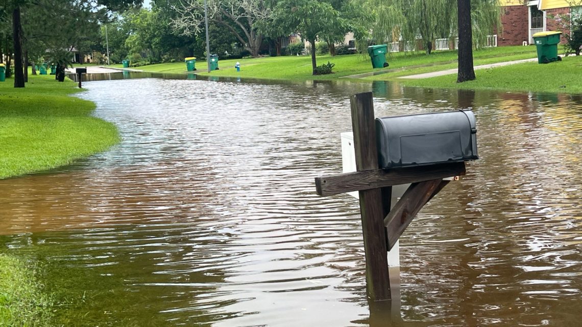
Kelleys Island Faces Unprecedented Rainfall
Ohio’s Kelleys Island recently experienced an extraordinary rainstorm, delivering roughly four months’ worth of rain in under 12 hours. This event, described by meteorologists as an unofficial record for the Lake Erie island, underscores a rising climate threat in the U.S. Midwest and Northeast. Between 13 and 16 inches of rain fell from late Sunday to Monday morning, overwhelming roads, homes, and businesses. The National Weather Service (NWS) issued flash flood warnings as water levels surged, leading to flooded basements and submerged roads.
Comparing Past Rainfall Records
Kelleys Island, a preferred vacation spot in Erie County about 4.5 miles from Ohio’s mainland, usually experiences 4.1 inches of rain in July, according to NWS observing program leader Brian Mitchell. The island’s recent downpour equaled nearly four times its normal monthly rainfall within mere hours, a volume that typically takes months to gather. The prior state rainfall record was 10.75 inches, set in August 1995 in Shelby County. Updating the official record for Kelleys Island could take several weeks.
WTOL chief meteorologist Chris Vickers noted measurements exceeding 17 inches of rain on the island, which caused widespread flooding and surpassed former records. Residents were advised to avoid flooded areas and conserve water as the local infrastructure struggled with the deluge. The rainfall more than doubled the NWS’s 1-in-1,000-year event parameters, where 8.41 inches in 24 hours is required in the area.
Understanding 1-in-1,000-Year Events
Some meteorologists mentioned the Kelleys Island rainfall bordered on a 1-in-1,000-year event. Despite this title, the term reflects a 0.1 percent chance of occurrence each year based on history and analysis. Multiple such events can occur in short periods, as the designation indicates probability rather than occurrence spacing.
With warmer air holding more moisture, storms nowadays can produce heavier downpours than in cooler climates. Research shows the atmosphere’s moisture capacity increases by 7 percent for every 1 degree Celsius (1.8 degrees Fahrenheit) of warming, allowing storms to release intense rainfalls.
Trends in Extreme Rainfall
The Kelleys Island flooding coincides with a national trend toward heavy precipitation events. Reports from the U.S. Global Change Research Program and National Climate Assessment reveal significant increases in the heaviest rainfall occurrences across the U.S. over the past century, particularly in the Midwest and Northeast.
While climate change doesn’t cause all storms, it influences conditions that enable storms to produce more rainfall. Communities in the U.S. have seen multiple “once-in-a-century” and “once-in-500-year” floods in quick succession.
The Role of El Niño
El Niño, marked by unusually warm water in the equatorial Pacific Ocean, impacts global weather patterns, including North American precipitation trends. Although it’s currently occurring, El Niño tends to affect broader and longer-term weather patterns rather than individual storm systems. The flooding on Kelleys Island was linked to a slow-moving storm complex known as “training” thunderstorms.
Next Steps for Recovery
As floodwaters recede, officials and residents evaluate the extent of the damage to roads, homes, and public infrastructure. Emergency managers are assessing if additional state or federal aid is necessary. In the meantime, no further weather warnings are in place for the area, per the NWS Cleveland office.
 Cold Weather Alerts and El Niño Influence
  Turning Home Food Waste into Compost: A Guide
  Chicagohenge: When Sunlight Aligns with City Streets
  Fat Bear Week 2026: A Look at the Contest and Its Competitors
  California Governor Declares Statewide Emergency Ahead of El Niño Storms
  EPA Rollbacks and the Impact on Indiana Communities