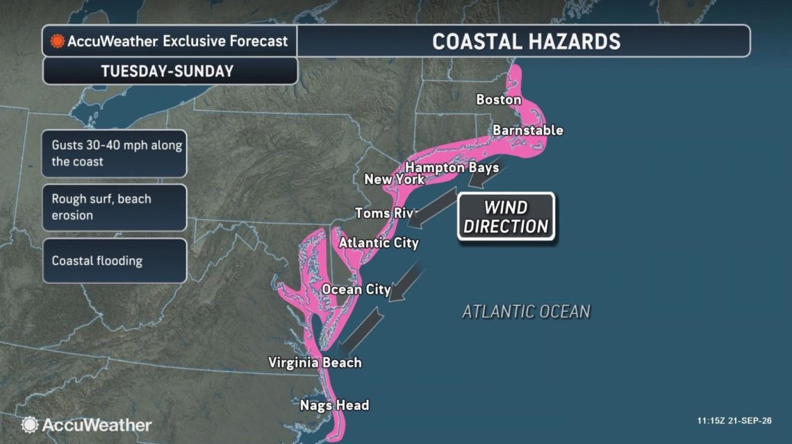
A developing nor’easter might bring severe weather to the East Coast this week. Forecasters are uncertain about the storm’s exact path and strength, which could impact the severity of the weather conditions. “A lot of the impacts will depend on where the storm develops and its track,” said AccuWeather meteorologist Alex DaSilva.
Understanding Nor’easters
The National Weather Service defines a nor’easter as a storm affecting North America’s East Coast, with winds usually coming from the northeast. These storms can occur any time of the year but are most common and intense between September and April. They typically bring heavy rain or snow, gale-force winds, rough seas, and occasional coastal flooding.
Current Forecasts
The Weather Channel noted that a low-pressure area might develop into a nor’easter off the Northeast coast by late this week. This system could disrupt travel and bring high surf, rain, wind, and coastal erosion. The channel highlighted a possible high-pressure system near the Great Lakes, which might strengthen winds as it nears the low-pressure system.
Different forecast models show various potential positions for the low. One suggests a path closer to the shore, which could bring stronger winds and more rain. Another model places the low farther offshore, suggesting fewer effects along the Interstate 95 corridor.
AccuWeather warned of coastal flooding from North Carolina to New York between Tuesday and Friday. The threat could extend along the northern Mid-Atlantic coast into southeastern New England over the weekend. The full moon later this week might elevate tidal levels, and the storm could further increase water levels.
DaSilva mentioned that regardless of storm development, gusty winds, heavy rain, and coastal flooding could impact the Northeast and mid-Atlantic later in the week. There is concern for power outages in coastal areas, where leaves still on trees may cause damage under the storm’s strong winds.
Potential Impact
FOX Weather forecasts major coastal flooding, extreme surf, and continuous rain in the Outer Banks, with wind gusts up to 50 mph. Offshore, waves could rise to 18 feet, and ocean overwash may affect coastal roads like Highway 12. Moderate coastal flooding is expected during high tides around vulnerable back bays and low-lying roads.
Elevated tidal flooding could eventually affect areas from North Carolina up to southern New England. The low-pressure system might move north toward the I-95 corridor and New England by the weekend. A path closer to Boston may result in wind gusts up to 70 mph, heavy rain, a major storm surge, and disruptions around Boston Harbor and the Massachusetts coast.
Alternatively, if the track lies nearer to Long Island or New Jersey, the strongest effects may shift south, with New York City potentially remaining on the storm’s periphery. If the low stays offshore, coastal New England may still experience rough surf and elevated tides, though the most severe winds and rains would remain over the ocean.
 California’s Growing EV Community Faces Challenges
  Massive Boulder Unearthed at O’Hare Airport Becomes Local Curiosity
  Trump’s Greenland Agreement
  Manhunt Underway for Armed Suspect in Placer County
  Midair Brawl Erupts on London-Bound Flight
  Passenger Jumps Overboard on Carnival Panorama Cruise