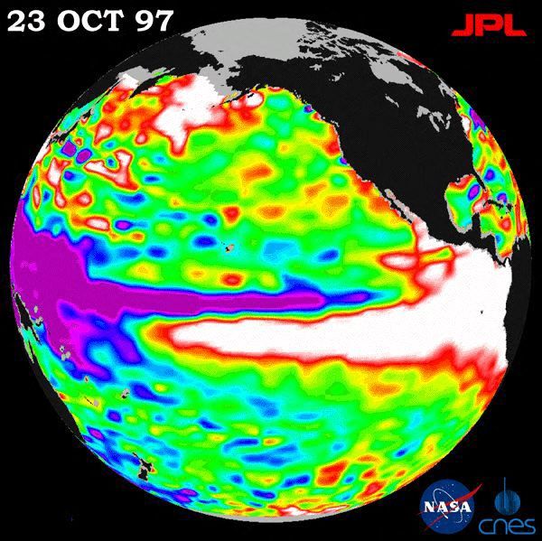
Current weather patterns point to this year’s El Niño possibly being the strongest on record. Columbia University climate scientist Azhar Ehsan noted similarities between this year’s atmospheric developments and the 1997 El Niño in a recent briefing. The 1997-1998 El Niño was marked by extreme weather conditions, becoming the second-warmest and seventh-wettest winter in the U.S. since 1895. It led to chaotic weather, with ice storms in the Northeast and severe flooding in the Southeast and California.
A NASA photograph from October 1997 shows significant changes in sea surface height as warm waters moved north along North America. Generally, an El Niño winter results in wetter conditions for southern regions and warmer, drier weather for northern areas. During the winter of 1997-1998, both warmth and significant rainfall impacted large parts of the country. California and North Dakota experienced their wettest winters. Florida, Maryland, Nevada, Rhode Island, and Virginia had their second-wettest winters.
Severe rains led to notable incidents: Tampa recorded over 15 inches of rain in December, while January brought over 19 inches to New Orleans, 17 inches to Mobile, Alabama, and 10 inches to Asheville, North Carolina. A severe storm in early January triggered floods, ice storms, and tornadoes in eastern North America, resulting in 56 fatalities across the U.S. and Canada, and widespread property damage.
In February, much of the upper Midwest and eastern states experienced the warmest weather on record. Cities in northern Montana did not record any temperatures below freezing during December 1997. By late February, Lake Erie near Buffalo remained unfrozen, with its water temperature at 36 degrees. A silver lining to this unusual weather was a 10% reduction in nationwide heating costs, a potential relief for rising energy expenses expected in 2026.
Moving forward, models suggest the 2026-2027 El Niño will surpass the intensity of the 1997-1998 event. This super-strong El Niño is anticipated to cause droughts in some regions and floods in others, with a potential 451,000 weather-related fatalities worldwide. During strong El Niño years, typical climatic patterns involve warm and dry weather in northern regions and cold, wet conditions in southern areas, with the dividing line shifting based on the jet stream’s position.
Forecasters report a 75% probability of 2026 witnessing a historical El Niño event exceeding previous records since 1950. Although El Niño peaks in winter, its presence this year has already affected late summer and early fall weather patterns. It contributed to a relatively calm Atlantic hurricane season while intensifying storm activity in the Pacific. Temperature and precipitation forecasts for the remainder of the year align with classic El Niño effects.
 Unprecedented Quiet: September Ends Without Atlantic Hurricanes
  Record-Breaking September Temperature in the U.S.
  States Lead the Way in Energy Policy
  Enhancements in Window Technology for Better Climate Control
  Climate-Resistant Rock Glaciers
  Bipartisan Senators Reach Permitting Reform Deal