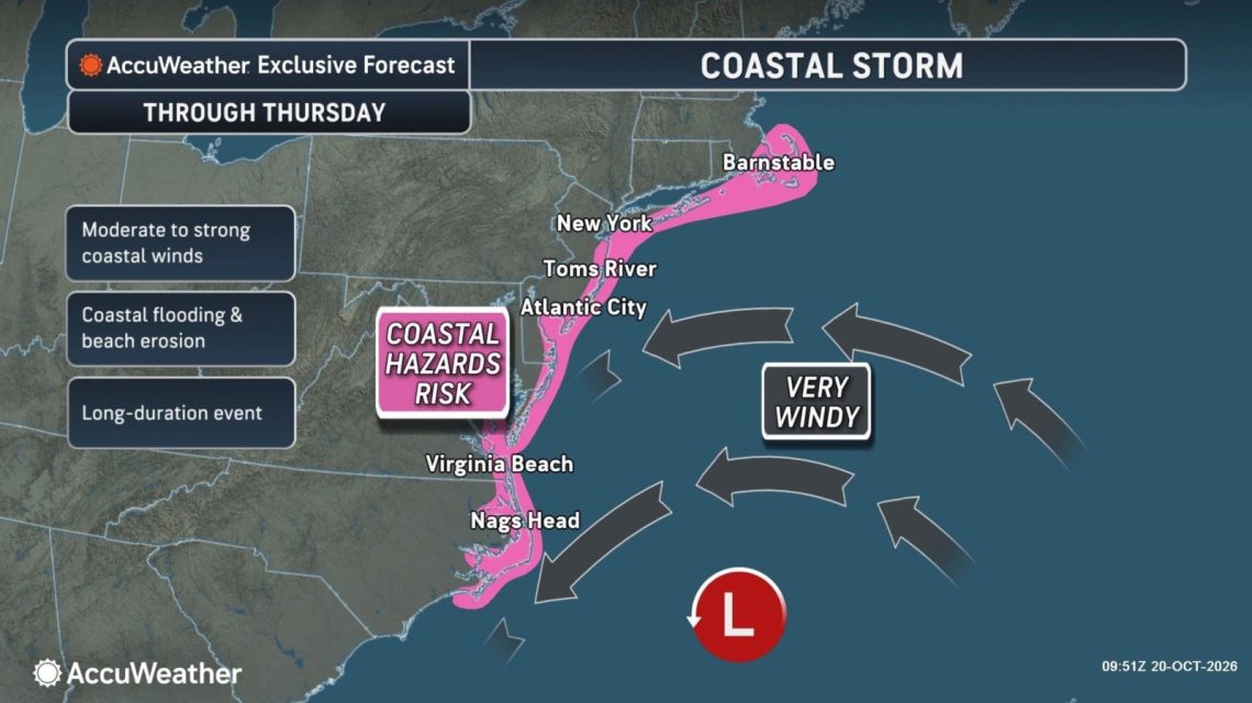
A nor’easter moving slowly along the East Coast poses risks of strong winds, coastal flooding, hazardous surf, and beach erosion from North Carolina to Massachusetts through Thursday. A forecast map presented to Newsweek highlighted the coastline from North Carolina to Massachusetts as under threat of “moderate to strong” winds and coastal impacts. The storm is expected to move gradually northward offshore, potentially gaining tropical or subtropical traits over the warm Gulf Stream waters.
As of Tuesday, the National Weather Service (NWS) issued coastal flood warnings for regions in New Jersey, Delaware, Maryland, and Virginia. The center of the storm will shift from waters off the Carolinas toward the mid-Atlantic, southern New York, and New England, extending coastal hazards northward during the week.
AccuWeather noted that much of the storm’s moisture would stay offshore, primarily affecting coastal communities while leaving many inland areas dry. The strongest winds from Morehead City, North Carolina, to Atlantic City, New Jersey, were anticipated through Tuesday, with gusts potentially reaching between 40 and 60 mph, and isolated 70 mph gusts possible. Breezy conditions are predicted to expand northward along coastal New Jersey, Long Island, southern Rhode Island, and Cape Cod later in the week.
Fox Weather forecasted hazardous conditions days ahead, with the most severe impacts extending through late Wednesday into Thursday. The most significant flooding threat stretches from the Outer Banks through Chesapeake Bay to Ocean City, Maryland, where water levels could rise over 2 feet above normal during high tide.
Forecasters indicated the possibility of the system becoming a subtropical or tropical storm. Alex DaSilva, AccuWeather’s lead hurricane expert, mentioned a moderate chance for the low-pressure area to gain tropical or subtropical features, with a higher likelihood of it being subtropical. Even if the storm achieves subtropical status, the National Hurricane Center can assign it a name.
Tropical systems derive energy from warm ocean waters, while subtropical systems use energy from both warm waters and the jet stream. DaSilva explained that nor’easters in October often attempt to acquire tropical or subtropical characteristics due to warm Gulf Stream waters capable of energizing these storms.
Regardless of classification, the mid-Atlantic coast may face coastal flooding, dangerous surf, and beach erosion this week.
Understanding a Nor’easter
The National Weather Service defines a nor’easter as a storm along North America’s East Coast, where winds over coastal areas predominantly come from the northeast. Though these storms can form year-round, they are most common and potent from September to April.
 U.N. Report Highlights U.S. Role in Rising Global Emissions
 Severe Weather Threat in Arizona and Southern California
 Michigan City Residents Urge NIPSCO’s Coal Plant Retirement Amid Environmental Concerns
 Gulf of Mexico’s Twilight Zone Ecosystem Severely Impacted by 2010 Deepwater Horizon Oil Spill
 Reassembling the F-117 Nighthawk at Smithsonian
 Lake Forest Preservation Symposium Emphasizes Community and Future