Severe thunderstorms in Illinois have sparked a remarkable event in 2026 with confirmed reports of 10 tornadoes over several days. This brings the total to an unprecedented 147 tornadoes this year, breaking the state’s previous record within just six months. Experts note that Illinois normally experiences 54 tornadoes annually from 1990 to 2020. The record-breaking 142 tornadoes seen in 2024 now seems modest compared to current figures.
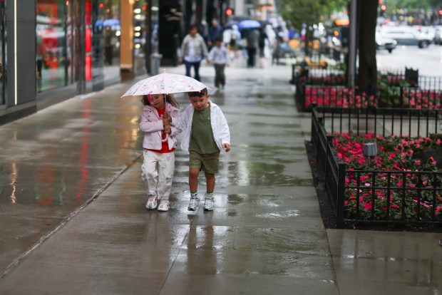
A NOAA study reveals Illinois’ pace is far from ordinary. By June 22, 2024, busy with tornado activity, only 91 tornadoes occurred in the state, highlighting the abnormal trend for 2026. Friends Deana Georgieva and Alex Kriltchev were spotted on a wet Michigan Avenue day June 21, 2026, reflecting the unprecedented weather conditions. During earlier years, specifically 2023, Illinois saw 121 tornadoes, followed by 142 in 2024 and 126 last year.
Data shows significant rise in recent years; Illinois only recorded over 100 tornadoes in four years prior to this stretch. Notable triple-digit occurrences last happened in 2006. “It’s a step change,” stated Trent Ford, Illinois State Climatologist. Preliminary data from NOAA’s Storm Prediction Center positions Illinois ahead of traditional Tornado Alley states like Iowa, Kansas, and Texas.
After brief respite, more severe weather struck Sunday. Northern Illinois faced heavy rain with potential flooding threats near I-88. Meteorologists predict drier conditions throughout early week, coupled with high swim risks along Lake Michigan due to dangerous waves and currents. “Quiet weather persists into midweek,” remarked Lee Carlaw, senior meteorologist at the National Weather Service office, noting chance of scattered showers.
Active start to the tornado season was triggered by March’s outbreak, setting stage for subsequent severe weather till June. On Sunday, tornado watch issued for parts of central and southeast Illinois. Tornado warning followed in Stewardson, Strasburg, Beecher City. Supercell thunderstorms elevated risks for hail, powerful winds, and tornadoes.
Confirmed tornado east of Louisville warned residents of Ingraham and Bogota. Weather service verified two more tornadoes in central Illinois including EF-2 in Charleston and Mattoon, EF-0 in Pawnee Junction. An EF-3 in Effingham caused significant damage, characterized by winds of 136-165 mph. Roofs were ripped off, homes destroyed, tree trunks snapped, and a van thrown 150 yards. Non-life-threatening injuries were reported.
Surveys revealed four more EF-1 tornadoes Friday night in Springfield, Blue Mound, Bethany, Grove Township. Springfield tornado followed similar path as one a week earlier. In Blue Mound, tornado damaged Bill and Susan Deetz’s home, tearing off elementary school roof.
Chicago office confirmed EF-0 tornado near Grayslake. Though weak, EF-0’s 65-85 mph winds can still inflict serious damage. Quad Cities confirmed tornadoes earlier. Climate change, releasing heat-trapping gases, contributes to intense thunderstorms possibly producing tornadoes.
Ford emphasized no satisfying explanation for Illinois spike. Climate change partly explains increased frequency; tornadoes occurring more in nontraditional months, lasting longer, starting sooner. Recent weather patterns initiated large tornado outbreaks during unusual months boosting numbers swiftly. “We’ve had tornado outbreaks previously,” Ford asserted.
La Niña pattern, prevalent in Midwest lately, coincides with severe spring weather. A potential slow next year, due to upcoming El Niño influencing the jet stream differently, might alter conditions. NOAA notes La Niña and El Niño shifts impact weather patterns across the U.S.
Chicago Tribune’s Jack O’Connor contributed additional insights into this weather phenomenon.
 Viking Age Discovery in Denmark Reveals Advanced Textile Production
  Rising Heat Poses Threat Across U.S., Authorities Warn
  Controversy Surrounds Lincoln Memorial Reflecting Pool Renovation
 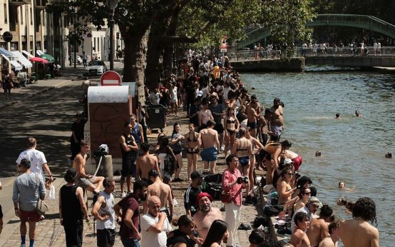 Europe Endures Intense Heat Wave with France Implementing Public Safety Measures
 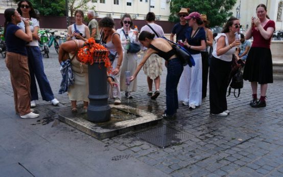 Europe Faces Intense Early Heat Wave Due to Heat Dome Phenomenon
  Abandoned Oil Wells in Illinois: A Growing Environmental Challenge