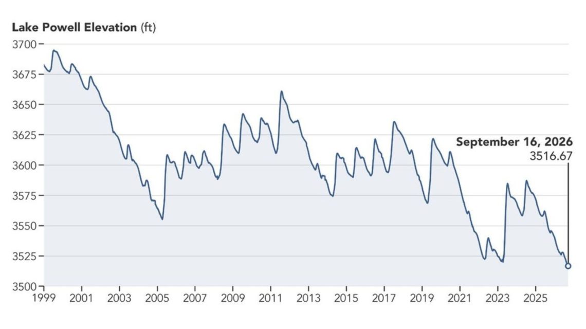
Recent satellite images highlight the significant retreat of Lake Powell over nearly a decade. The images compare the area near Glen Canyon Dam between September 1, 2017, and September 10, 2026. A prolonged drought has played a role in the reservoir reaching its lowest recorded level.
NASA noted that Lake Powell’s water level in 2017 was among the highest of that decade. However, the image from September 10, 2026, reveals notably less water. At that time, the water level stood at 3,517.24 feet. This was about a month after falling below its former record low of 3,519.92 feet, a mark set in April 2023.
The Importance of Lake Powell and the Colorado River System
Lake Powell is the second-largest reservoir in the United States. It is located on the drought-affected Colorado River, which stretches around 1,400 miles. The river supports seven states—Arizona, California, Colorado, Nevada, New Mexico, Utah, and Wyoming—as well as Mexico.
The Colorado River is vital, providing municipal water for tens of millions. It also supports hydropower, recreation, fish, wildlife, and millions of acres of agricultural land.
Record Lows in Major Colorado River Reservoirs
NASA released these images following record lows in both Lake Powell and Lake Mead, the largest reservoir in the nation, in August. The Bureau of Reclamation, responsible for managing these reservoirs, reported that these new lows followed a record-low winter snowpack in the Colorado River Basin during 2025-2026.
Sarah Porter, director of the Kyl Center for Water Policy at Arizona State University, commented on Lake Mead’s discouraging but expected low. “The reservoir will likely recover somewhat this winter, especially with a heavy snowpack, but the overall decline over the last 25 years means one good winter won’t suffice to stabilize the system long-term,” she stated previously to Newsweek.
To counteract declining water levels in Lake Powell, federal water managers announced measures in April. These include releasing water from the upstream Flaming Gorge Reservoir and reducing releases from Lake Powell to Lake Mead downstream. The Bureau of Reclamation warned that without significant intervention, declining water levels could threaten hydropower production at Glen Canyon Dam.
Potential Increase in Lake Powell Levels
New federal projections suggest that Lake Powell’s level might rise by 40 feet over the next two years. However, Lake Mead’s levels could decrease by a similar amount. According to the Bureau of Reclamation’s “most probable” September 2026 24-Month Study, under a scenario where 6 million acre-feet of water is released from Lake Powell in the 2027 operating year, Lake Powell might reach 3,558.44 feet by June 2028. On the contrary, Lake Mead could drop to 998.40 feet by August 2028.
For comments, contact Newsweek editor Edward Pearcey.
 Florida Citrus Growers Use Gene-Editing to Combat Citrus Greening
  Tropical Depression Six Forms in the Atlantic Amid Quiet Hurricane Season
  Fat Bear Week: Celebrating Resilient Giants and Ecosystem Conservation
  Concerns Surface Over SpaceX Facility in Louisiana
  Understanding Pyrocumulonimbus Clouds Through NASA’s INSPYRE Mission
  Transitioning from Pig Farming to Mushroom Production in Iowa