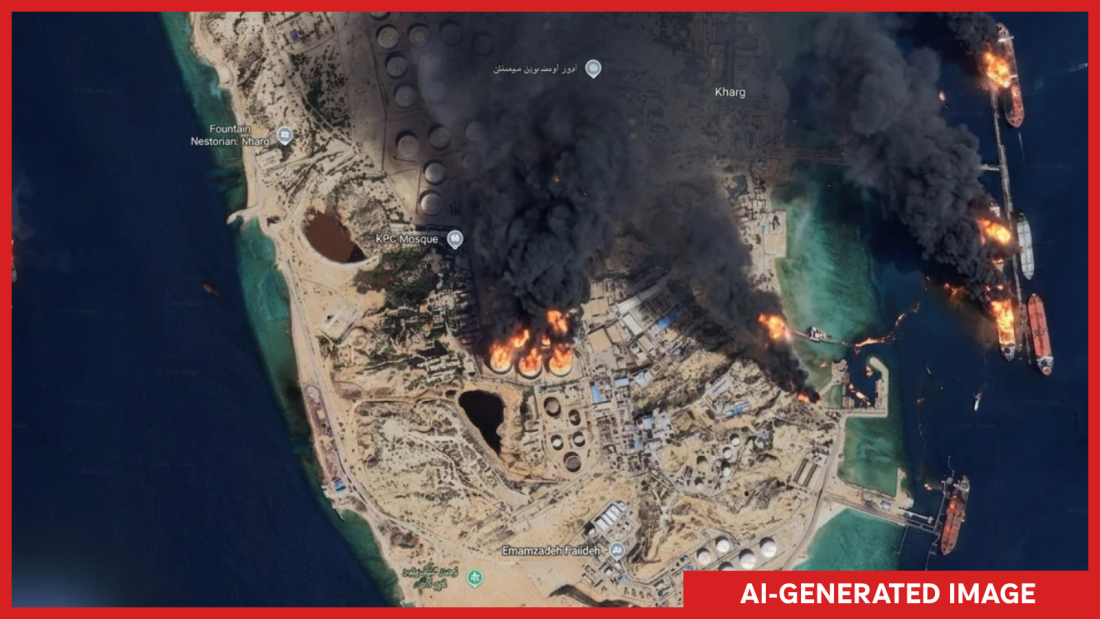
An AI-generated image depicting fires on Kharg Island ignited concerns over a new feature by Google that allowed users to create AI satellite images. This Iranian island, located in the Persian Gulf, hosts a significant oil terminal.
Google introduced a feature enabling AI-generated satellite images through its Google Earth platform. Users could click a button to create images, designed initially for imaginative uses. However, Google quickly retracted the feature after users shared screenshots that violated its policies.
The company’s statement cited uses by geospatial professionals, but abuses prompted a rollback to implement better safeguards. In its initial unveiling, the tool allowed users to zoom in and create images by typing desired scenes. Concerns arose over potential misuse, especially by experts and analysts relying on legitimate satellite imagery to verify breaking news and events in remote areas.
The capability to fabricate deepfake satellite images at the touch of a button worried many professionals.
Henk van Ess, an open-source researcher, expressed concerns after testing the tool with scenarios like a refugee crisis at the Mexican border and others. NPR demonstrated the tool’s capability by generating nonexistent scenes like Kharg Island on fire and a flooded U.S. Capitol, both fictional events that could trigger significant news if real.
Visual forensics investigator Evan Hill questioned whether Google tested the potential for abuse internally before releasing the tool. The risk of disinformation with AI-generated satellite images remains high, threatening the reliability of satellite imagery as a verification tool. Historically, satellite images, controlled by companies or institutions, provided a robust method to confirm events.
Actual fake satellite images have appeared, such as during the U.S.-Iran conflict featuring a fictitious damaged base in Bahrain. However, the advent of a tool simplifying this process raises the likelihood of more artificial images proliferating. Misinformation disseminates quickly and can surpass efforts to correct it, adding layers of confusion.
Google addressed these concerns, noting that all images carry a SynthID watermark to identify AI-generated content in other Google tools. The company emphasized its commitment to preventing harmful image creations and updating protections. Despite these assurances, skepticism lingers within the open-source community. Google Earth’s reputation as a verification tool could suffer if the line between genuine and fabricated imagery blurs.
Van Ess stressed that if Google continues developing the AI tool, it risks compromising a resource that users rely on to verify the authenticity of images shared online.
 Pentagon Confirms US Weapons Deployed in Space
  Protecting Your Finances from Increasing Cyber Threats
  Scammers’ Strategic Tactics: When and Where You’ll Be Targeted
  King Charles III to Address AI Concerns with Top Companies
  How AI is Transforming the Landscape of Scams
  Seth Bodnar’s Campaign Targets Surveillance Cameras in Montana Senate Race