Flash Flood Threat in the Gulf Coast and Lower Mississippi Valley
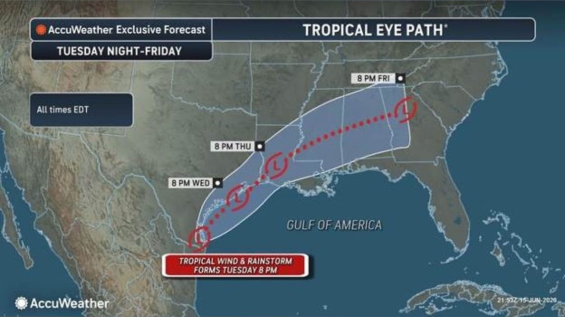
Millions in the Gulf Coast and Lower Mississippi Valley face a significant threat of flash flooding as a weather system near Texas could evolve into a tropical storm. The system currently generates widespread showers and thunderstorms near the Texas-Mexico border, bringing tropical moisture that may cause intense rainfall over several days.
Should a tropical storm materialize, it would be named Arthur as per this year’s list. Forecasters emphasize that rainfall volume poses the most danger, rather than wind strength. Potentially, repeated rounds of tropical downpours might exceed drainage capacity, leading to hazardous flash flooding and rivers rising quickly in already saturated regions.
Weather System Near Texas Shows Potential for Strengthening
According to the National Hurricane Center (NHC) in a Tuesday morning update, a trough of low pressure near the Mexico-Texas border results in disorganized showers and thunderstorms over a broad area.
The system could reemerge over the northwestern Gulf of America today. Conditions might marginally support forming a short-lived tropical storm later today or Wednesday, the NHC stated.
Regardless of tropical cyclone formation, southern and eastern Texas and parts of Louisiana and Mississippi should brace for intense rainfall that could result in life-threatening flash, urban, and river flooding over the coming days, the NHC advises. There’s potential for gusty winds and coastal flooding along the northwestern Gulf Coast, with tropical storm watches or warnings likely if the system continues to develop.
Flooding Concerns Highlighted by Forecasters
AccuWeather forecasters informed Newsweek via email about a potential tropical rainstorm forming on Tuesday. This term draws attention to tropical systems posing flood risks even without an official name.
Forecaster Dan DePodwin, AccuWeather’s vice president of forecasting operations, expressed worry about repeated rounds of torrential rain powered by tropical moisture. He noted that similar weather patterns have historically led to significant flash flooding events.
Areas at Greatest Risk
AccuWeather forecasts indicate that heavy rain from the system could extend from eastern Mexico, through Texas and parts of the Gulf Coast, before moving northeast later in the week. Rainfall rates might peak at 2 to 4 inches per hour in the most severe storms, heightening the danger of rapidly rising waters, especially in urban areas such as Houston.
Possibility of Becoming Tropical Storm Arthur
Currently, flood watches from the National Weather Service cover southern and southeastern Texas, much of Louisiana, and parts of southern Mississippi. The Atlantic hurricane season began on June 1 and will end in November. The National Oceanic and Atmospheric Administration forecasts a below-normal season with eight to 14 named storms expected.
The NHC continues to track the disturbance, providing regular updates on its website as development progresses.
 Roy Cooper Leads Michael Whatley in North Carolina Senate Race
  Rising Heat Poses Threat Across U.S., Authorities Warn
  Trump Nominates Lawyer Connected to His Taxes for IRS Counsel
  Efforts Intensify in Search for Missing Mother of Savannah Guthrie
  18-Year-Old Arrested in Fatal Shooting at California Library
  Controversy Surrounds Lincoln Memorial Reflecting Pool Renovation